UDMN Award of Excellence
Geoscience INTEGRATOR wins - Last December, UDMN presented us with an Outstanding Achievement in Commercialization...


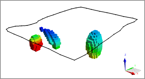
Our team carefully assesses all the data available and weighs it against the prevailing conceptual geological model. Geophysical and geochemical data is used to improve initial geological models at multiple scales. These practices converge to create a model that geoscientists can trust, diminishing the risk in applications from targeting model generation to geotechnical hazard assessment.
The Mira Geoscience team has been busy using novel approaches to interpretation developed through our internal research. In 2021, we applied cutting-edge technology such as the use of discrete fracture networks in development of high-grade vein predictive models, deep-learning generative networks for targeting and geophysical feature analysis, data-driven structural interpretation using unsupervised learning, and automated geological map generation from multi-layer geophysical data. We are developing new methods of filtering gridded magnetics and gravity data to remove signal related to geological cover sequences. We have continued to develop and refine our unique workflow for applying AI to geohazard assessment, where our focus has been 4D integrated modelling of geology, rock mass characterization, stress, ground deformation, production, and infrastructure. We have recently been asked to provide insights into underlying patterns and to forecast hazard probabilities in several deep rockbursting mines internationally, including both conventional underground and cave mines. Have a look at our team’s profiles and the case studies that highlight their achievements.
”“Having Mira Geoscience working with us in is a catalyst for our own group’s thinking. It helped us to question and refocus our own attention and challenge our assumptions. Spending on 3D modeling and AI consulting to be able to target our drilling better, was far more constructive for our exploration efforts in the long run than to just go in, you know, on a gut feel. It puts us miles ahead.”
Hugh Agro, P.Eng.President & CEO of Revival Gold Inc

John McGaughey
President & Geoscientist
Geophysics

Scott Napier
Principal Geoscientist
Geophysics

James Reid
Principal Geoscientist
Geophysics

Glenn Pears
Principal Geoscientist
Geophysics

Chrissy Williston
Geoscientist
Geophysics

Aurore Joly
Senior Geoscientist
Geology

Gem Midgley
Principal Geoscientist
Geology

Thomas Campagne
Senior Geoscientist
Geophysics

Carla González
Geoscientist
Geology

Stephanie Howe
Senior Geoscientist
Geology
Fabiano Della Justina
Geoscientist
Geophysics

Polyanna Rowe
Geoscientist
Geophysics

Marko Gauk
Geoscientist
Data Management
Expertise in quantitative, multi-disciplinary 3D/4D interpretation for mineral exploration and geotechnical decision support. Leads our technology strategy.
John is the founder and President of Mira Geoscience. He has extensive mining industry experience as a thought leader in quantitative, multi-disciplinary 3D and 4D interpretation for mineral exploration and geotechnical decision support. He currently leads our technology strategy and our geotechnical business. Early on, as it was being initially developed by researchers in the oil and gas industry, John recognized the value of the “Common Earth Model” concept for building 3D geological models consistent with geological, geophysical, and physical property data.
He brought the same disciplined thinking to integrated modelling in the minerals industry, in the process adapting and marketing a key oil and gas technology as GOCAD Mining Suite, one of Mira Geoscience’s flagship products. More recently, he originated and led our development of the Geoscience ANALYST and Geoscience INTEGRATOR platforms. His current technical focus with customers is in 4D data integration and AI solutions for geotechnical hazard assessment.
Prior to founding Mira Geoscience in 1999, he spent 10 years at the Noranda Technology Centre as a Senior Scientist in their rock mechanics group. He obtained an MSc in Geological Engineering and a PhD in Geophysics from Queen’s University. John is based in Montreal.
Expertise in geophysical inversion, along with extensive borehole, ground, marine, and airborne EM interpretation, modelling, and processing.
Scott is a Principal Geophysicist who brings substantial expertise in geophysical inversion, along with extensive borehole, ground, marine, and airborne EM interpretation, modelling, and processing experience. His experience in project management, geoscience knowledge, focus on exploration relevant outcomes, and flexibility in decision-making is a great asset to exploration strategies and exploration teams.
He has worked in Canada and internationally on oil and gas, uranium, and base metal exploration teams, with a track record of proven discovery. Scott has field experience in the collection of geophysical data, including management of crews in the field. He has significant experience in the processing, modelling, and interpretation of electromagnetic data along with advanced processing and interpretation of many other types of geophysical data.
Before joining Mira Geoscience, Scott worked for CanAlaska Uranium, Lundin Mining, and AGO Geomarine Operations. He has an MSc in geophysics from UBC. Scott is based in Vancouver.
Expertise in integrated interpretation and talent for finding models that answer all the data. Planning and quantitative interpretation of airborne EM to mineral exploration and groundwater geophysics.
James is a Principal Consultant with 25 years’ experience in mineral exploration. He is currently Director, Mira Geoscience Asia-Pacific. He provides new geoscientific insights to complex mining industry challenges. James has a broad interest in integrated interpretation of geophysical and geological data and has a talent for finding models that answer all the data. He has extensive expertise in the planning and quantitative interpretation of electromagnetic and electrical methods, particularly the application of airborne electromagnetics to mineral exploration and groundwater geophysics. James’ wide spectrum of professional experience and his problem-solving skills give him the ability to handle difficult or unexpected technical challenges.
Before joining Mira Geoscience, James was a lecturer in Geophysics at the University of Tasmania from 1999-2006, and a consultant with Geoforce and Groundprobe Geophysics from 2006-2012. He has an MSc in geophysics from the University of Sydney and a PhD in geophysics from Macquarie University. James is based in Perth.
Leading experts in geologically-constrained inversion of geophysical data sets. Expert in data assessment, QA/QC, developing modelling strategies.
Glenn is a highly experienced geophysicist providing expertise in data integration and interpretation projects over a wide range of commodities. He is one of the world’s leading experts in geological model construction from multi-disciplinary geophysical data sets. Glenn has over 20 years of extensive 3D modelling experience and provides a strong background for data assessment, QA/QC, developing modelling strategies and executing integrated interpretations. His strengths are in geologically-constrained geophysical interpretation and inversion, but he extends this skill to working collaboratively with geologists to develop 3D geological models directly from geophysical data. Glenn has an insight for identifying how a geological model needs to evolve to satisfy the geophysical data.
He is a practised and knowledgeable trainer in potential fields inversion and has hosted multiple workshops for modelling and inversion software. Glenn has contributed to software development including Mira Geoscience’s GOCAD Mining Suite, as well as inversion algorithm (VPmg/VPem1D) development, processing algorithms for potential field and AEM data and continues to use his programming skills to generate innovative solutions as part of his work.
Glenn previously occupied positions at World Geoscience, Fugro Airborne Surveys, and Quantec Geoscience. He obtained an MSc from the University of Queensland. Glenn is based in Brisbane.
World-class geological modeller with vast experience in working with very sparse data, and generating high priority drill targets.
Chrissy is a world-class geological modeller with a strong geophysics background. From implicit to explicit modelling, working with very sparse data, and generating high priority drill targets, Chrissy has years of experience constructing 3D multi-disciplinary integrated models for a wide variety of mineral exploration and mining applications. She has worked in extensive geologic modelling environments across numerous commodity types on projects around the world. She’s been involved with minerals exploration and mining projects, geothermal exploration projects, research projects and 4D geohazard mapping projects. Chrissy works with clients through consulting, training, and remote support, and has acted as the Product Development Manager for Geoscience ANALYST.
Prior to Mira Geoscience, Chrissy worked for a geophysical consulting company in Canada and was involved in various projects worldwide. She obtained a BSc Honours degree in Earth and Atmospheric Science at York University in Toronto. Chrissy is based in Miramichi.
Expertise in integrated 3D geological and geophysical exploration, mineral system analysis, and de-risking modelling exercises by focusing on geological features.
Aurore brings 15 years of mineral exploration experience including expertise in integrated 3D geological and geophysical exploration. Aurore’s multi-disciplinary skills allow her to tackle almost any type of data and put them into a geological context. She is an expert in mineral system analysis, which helps de-risk modelling exercises by focusing on key geological features. Aurore has worked in numerous commodities—in geological terranes ranging from Archean to Eocene in age, including gold, copper, zinc, nickel, uranium, amongst others. Aurore specializes in GIS-based mineral system targeting, helping our customers make their next discovery in the greenfield exploration space.
Before joining Mira Geoscience, Aurore did consulting work for Resource Potentials, Aurora Australis Geoconsulting, and St Barbara. She holds an MSc in Earth Sciences and a PhD in Geophysics from the University of Orleans, France. Aurore is based in Perth.
Geological, geochemical, petrophysical, and seismic data modelling and interpretation. Expertise in mineral systems modelling and exploration targeting.
Gem is a professional geoscientist with diverse experience in minerals exploration, geoscience research, and consulting. For more than 25 years, she has provided technical leadership and domain expertise in integrated, multi-disciplinary mineral systems modelling and exploration targeting.
Gem has expertise modelling and interpreting geological, geochemical, petrophysical, and seismic data. She has experience in product development, implementing technology solutions to improve customer success, and assessment of project strategy.
Before joining Mira Geoscience, Gem worked with global resource companies and world-leading research organizations including Placer Dome, AngloGold, and CSIRO. She holds a Masters in Economic Geology from the University of Tasmania and is a member of the Australian Institute of Geoscientists, MAIG. Gem is based in Adelaide.
Geophysical data processing and interpretation, 3D geologically-constrained inversion modelling, and integrated interpretation of potential fields data.
Thomas is an experienced geophysicist with skills in interpretation for mineral exploration. His systematic approach to geophysical data processing and interpretation has evolved into 3D geologically-constrained inversion modelling and integrated interpretation of potential fields data. Thomas has developed numerous novel approaches to data processing and preparation to help guide sensible constrained inversion and target modelling. His expertise in data pre-processing and scripting are key contributing factors to the success of the team.
Thomas is an experienced trainer in 3D geophysical modelling in GOCAD Mining Suite and VP Geophysics Suite.
Before joining Mira Geoscience, Thomas gathered experience supervising and conducting ground geophysical surveys including IP, TDEM, and magnetics. Thomas obtained his MSc in Geophysics from l’École et Observatoire des Sciences de la Terre de Strasbourg, France. Thomas is based in Vancouver.
Data integration, scripting, as well as the creation of 3D and 4D mining, geological, and geotechnical models for mineral exploration and geohazard assessment.
Carla has a background in 3D geoscience software technical support and training. She is experienced in the creation of instructional content, software testing and troubleshooting, and geotechnical hazard assessment modelling.
Through her work at Mira Geoscience, Carla has gained experience in data integration and scripting, as well as the creation of 3D and 4D mining, geological, and geotechnical models for mineral exploration and geohazard assessment. She has also supported Mira Geoscience’s clients with 3D geoscientific data visualization and modelling in GOCAD Mining Suite and Geoscience ANALYST.
Prior to joining us, Carla did geological field work with Apex Geoscience, Maple Gold Mines, and Pretium Resources. Her field background includes surface and underground exploration, core logging, and working alongside drill programs on various Canadian projects. Carla has a BSc in Earth and Planetary Sciences from McGill University. She is fluent in English, Spanish, and French, and is based in Montreal.
Experience in 3D geological modelling, potential fields inversions, EM inversions, and 4D-GIS geotechnical hazard modelling and assessment.
Stephanie is an experienced geoscientist with over 10 years of experience in geophysics and geotechnical engineering. Stephanie works with clients through consulting, training, and support both on site and remotely. She is proficient in 3D geological modelling, potential fields inversions, EM inversions, and 4D-GIS geotechnical hazard modelling and assessment. Stephanie has also created and edited documents used for software training as well as reports for clients.
Stephanie has previous experience in the field in exploration working with KUTh Energy. Here she worked on diamond and RAB drill rigs in New South Wales and Tasmania mapping, soil sampling and laying out IP Surveys. Stephanie obtained a B.Sc. (Hons) from the University of Tasmania, Australia. She is based in Brisbane.
Experience in geophysical survey techniques applied to mineral exploration including but not limited to AFMAG, MT, gravity, magnetics, EM, radiometric.
Fabiano has been engaged professionally and academically in a variety of geophysical survey techniques applied to mineral exploration including but not limited to AFMAG, MT, gravity, magnetics, EM, radiometric. He has demonstrated versatility with proven ability to design survey, conduct fieldwork/calibrations, analyze data, and generate geophysical models.
Fabiano is an experienced geoscientist with proven contribution for world-class geosciences initiatives such as: Airborne Geophysical Surveys of Brazil, Airborne Geophysical Project of Republic of Congo, and Metal Earth Project (Canada).
Fabiano is based in Sudbury.
Geophysicist and Python programmer with a research background in potential fields geophysics and data analytics.
Polyanna has wide experience in 1D–4D forward and inverse geophysical modelling, and multisource geoscientific data integration and analytics to optimize minerals systems targeting. Her main geophysical expertise includes the processing and interpretation of ground and airborne gravity and magnetic data, satellite gravimetry and altimetry, and gamma ray spectrometry data. Additionally, she has specialized expertise in the visualization and interpretation of seismic tomography and deep reflection seismic data, geophysical logging data and heat flux data.
Polyanna has previously worked on 3D earth modelling, data integration, and interpretation projects. These include mafic-ultramafic orthomagmatic and basin-hosted mineral systems signatures in the Pilbara Craton margin, Rudall Province, and Canning Basin in Western Australia, as well as various regions of South America.
Polyanna is based in Perth and works with clients through consulting, training, and support.
Experience with geoscience data processing as well as with software training and support.
Marko has 10 years of experience with geoscience data processing as well as with software training and support. His technical skills include programming and the use of several geoscience software applications. As a data management and modelling analyst, he works on geotechnical and exploration projects, modelling geoscientific data, preparing inputs for machine learning analysis, and populating client data in data management systems.
Before joining Mira Geoscience, Marko worked for SeisWare International. He has a Bachelor of Science degree with Specialization in Geophysics from the University of Alberta. Marko is based in Calgary.