


In the upcoming GOCAD Mining Suite v19, you can reshape your surfaces and 2D Grids with a spiderweb editing tool.
With this tool, you can reshape the surface in a circle of a given radius. You can enter the radius manually or interactively change it with the middle-mouse wheel.

You will find this tool in the Surface menu > Tools > Surface Editor, in the Edit with Spider Web tab or in the Digitization/ Editing toolbar for surfaces or 2D Grids (when object is selected).
Previous tips can be found under the Software tip category in the News section and in the Archives section of our website.
Latest news

Searching in the objects tree
Having trouble finding one object out of hundreds in Geoscience ANALYST? Try searching your Objects panel (Ctrl+F)...

Editing property’s colormap
In GOCAD Mining Suite, when you select a property its colormap can be edited...

Copying objects between Workspaces
In Geoscience ANALYST objects can be copied from one Workspace to another by using Ctrl+C and Ctrl+V...

DC resistivity inversion in Geoscience ANALYST Pro Geophysics
Past event, view here or via our YouTube channel...

Improved scatter plots
In Geoscience INTEGRATOR, you can can increase/decrease the node size, take snapshots, zoom in on an area of interest...

Scripting – Geoscience ANALYST Pro – Virtual Lecture
Past event. Have a look at the video to learn about mathematical and logical scripting in Geoscience ANALYST Pro...
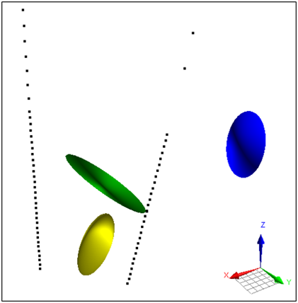
Parametric Ellipsoid Modelling in Geoscience ANALYST Pro Geophysics
A Fast New Way to Interpret TEM Anomalies. Read more >>

New filter options on the File manager and the Maps/plans/sections
In Geoscience INTEGRATOR, you can now find files quickly by using the new extension, tags and uploaded by filters...

15 tips in 15 minutes – Geoscience ANALYST Free Viewer
Past event, view here or on our YouTube channel...

Themes
Geoscience INTEGRATOR v3.5 and Geoscience ANALYST v3.2 include new themes and renamed ones to help you to locate data in a more intuitive way.

Q&A with VR Resources
Join us in this exciting conversation with Michael Gunning on how to find success in blue-sky exploration through integrated interpretation of magnetic data and structural geology

Documents linked to a project
When documents are linked to a project in Geoscience INTEGRATOR, it is possible to be more specific and link them to the project’s data sets...