


For each project, system administrators give users different levels of permission by role-based access. Depending on their role, users will see different menus, buttons, or options between projects and colleagues.

In this example, Paul B has a “limited” role and Marie A has a “project manager” role. Note that system administrators can either use default roles or create new ones.
Previous tips can be found under the Software tip category in the News section and in the Archives section of our website.
Latest news
Automatic calculation of XYZ for drillhole sample location
In Geoscience INTEGRATOR, drillhole sample locations are automatically computed as XYZ by the system from the deviation surveys...

Coordinate system transformations
In Geoscience ANALYST Pro version 4.0, you can apply coordinate system transformations to...
New release – Geoscience ANALYST 4.8
Geoscience ANALYST 4.8 delivers exciting new enhancements across all product options. Upgrade today!

Drillhole Statistics
In Geoscience ANALYST you can compute drillholes’ deviation statistics. These include...

Revolutionizing Subsurface Interpretation and 3D Visualization with Geoscience ANALYST Pro
Discover how EnBW is bridging the gap between 2D mapping, 3D seismic interpretation, and integrated geophysical workflows

Linking viewports
In Geoscience ANALYST you can synchronize the perspective of all visible Viewports to zoom, pan, and rotate them all at once...

Advanced drillhole planning and monitoring
We partnered with Groupe MISA to develop a low-cost 3D application where all elements of drillhole design and monitoring...

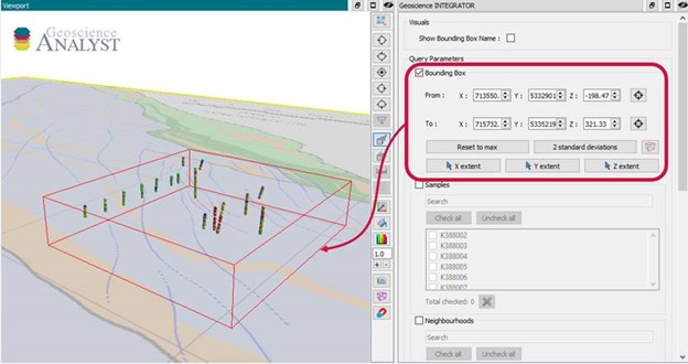
Data fusion – Automatic sample compilation
In Geoscience INTEGRATOR, the Sample compilation page offers powerful tools to support the analysis of complex or difficult-to-view relationships within your sample data...

Coordinate display area
In Geoscience ANALYST you can get real-time feedback on the XYZ coordinates corresponding to the...
..

Editing property’s colormap
In GOCAD Mining Suite, when you select a property its colormap can be edited...

Getting started with the Python geoh5py
Past event, view here or via our YouTube channel...

Show and hide
In Geoscience ANALYST you can show and hide everything, individual objects, container groups or drillhole groups...