

Geoscience INTEGRATOR + Geoscience ANALYST
Your Integrated 3D Platform for Exploration and Data Management
Transform complex geoscience data into actionable insights with a powerful software duo designed to unlock the full potential of your data, streamline workflows, and enhance multi-disciplinary collaboration. All while keeping your software spend under control.


Introducing a Powerful Geoscience Software Duo
✔ Customizable, Collaborative, and Built Around Your Workflows
✔ Where Geoscience Data Meets Advanced Interpretation
✔ The Platform of Choice for Exploration Leaders
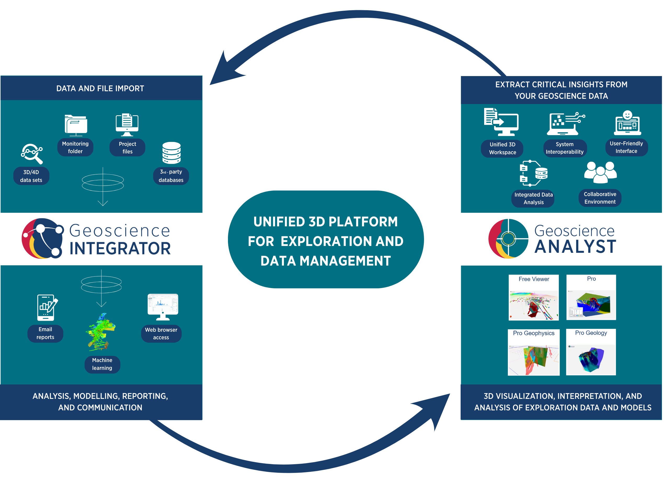
Geoscience INTEGRATOR and Geoscience ANALYST form a powerful, integrated platform built for mineral exploration and data management. Together, they provide a seamless environment for managing, visualizing, and interpreting complex geoscience data across disciplines—helping your team move faster from data to decisions.
Whether you are a junior explorer, a mid-tier, or a major mining company, this integrated solution scales with your needs, improves collaboration, and keeps software costs manageable without compromising performance or flexibility.
Evaluate your project faster
Accelerate decision-making with a fully integrated 3D data management solution that reduces costs of switching between tools and disciplines.
Extract more insight from your data
Bring together geological data with geophysical, geochemical, and structural data for holistic interpretation, analysis, and modelling—all in one environment.
Work from a single, validated source of truth
Avoid data loss, duplication, and errors with centralized governance, version control, and built-in validation tools.
Ensure data integrity at every stage
Use structured data management workflows that enforce standards, validate inputs, and maintain audit trails—giving you confidence in your outputs.
Adapt your data structure to match your workflow
Configure schemas, relationships, and data integration rules to align with your operational logic—so the system works the way you do.
Integrate open-source and Python with ease
Share projects with the GEOH5 open format and extend the platform with geoh5py and Python scripting—connect to your tools without being locked into a black box.
Collaborate more efficiently
Work across teams and disciplines in a shared 3D environment with consistent, live access to all project data and interpretations.
Scale your platform with your project
From grassroots exploration to advanced resource modelling, the platform adapts to your technical complexity and data volume.
Built with—and for—exploration professionals
The product roadmap is shaped directly by customer feedback, ensuring it evolves to solve real exploration challenges.
Back Your Project with Data-Driven Credibility
Your early-stage exploration data holds untapped value. With Geoscience INTEGRATOR + Geoscience ANALYST, you can retain, organize, interpret, and share all your project data—drillholes, geology, geophysics, geochemistry, interpretations, and more—over time in one connected platform. Keep your project history complete and transparent, ready to present to investors, partners, or acquirers who can easily explore it in 3D.
With flexible tools and the GEOH5 open format, you can build rich, data-backed insights that clearly demonstrate your project’s value. It’s not just about faster workflows—it’s about establishing technical credibility and boosting your project’s potential from day one.

Show your project’s full potential!

Bring Clarity and Consistency to Every Project
Get more out of your data with a unified platform built for multi-disciplinary geoscience data integration. Whether you’re managing multiple sites, advancing brownfield projects, or evaluating acquisition targets, our customizable 3D platform—Geoscience INTEGRATOR + Geoscience ANALYST—keeps your teams aligned and your data consistent.
Work from a validated source of truth with centralized data governance, version control, and cross-team collaboration tools. Built-in Python integration and automation options let you tailor workflows to fit your operation—no matter how diverse your data sources or objectives are.
Standardize your workflow across projects!
Deliver Enterprise-Scale Exploration with Confidence
Manage complex, global projects demands in a 3D platform that ensures data integrity, rigorous validation, and seamless integration with your existing systems. Our scalable platform—Geoscience INTEGRATOR + Geoscience ANALYST—supports advanced interpretation and modelling workflows, while enforcing centralized standards to keep your data consistent across all teams and regions.
Designed for large, multi-disciplinary operations, the platform empowers collaboration across geographies and disciplines. Open-source tools and customizable workflows empower your teams to innovate while maintaining strict control over data quality, compliance, and reporting—helping you reduce risk and accelerate project delivery.
