


In Pro version 4.0, you can apply coordinate system transformations to Points, Curves, Surfaces, and 2D Grid objects, from current to targeted Coordinate Reference System.
Utilities menu > Coordinate System Transformation > Geodetic tab

If upon import your raster data already contained coordinate system information, this is saved in the object’s metadata.
Otherwise, all other object’s coordinate systems are set as unknown and can be defined.

Previous tips can be found under the Software tip category in our Resources page and in our Archives page.
Latest news

Scripting – Geoscience ANALYST Pro – Virtual Lecture
Past event. Have a look at the video to learn about mathematical and logical scripting in Geoscience ANALYST Pro...

Free mineral exploration data through Geoscience ANALYST
Past event - view here or on our YouTube channel...

Attending AME Roundup 2026?
Visit us at booth 416 to see our software solutions in action and discuss your needs with our expert team!

Coordinate display area
In Geoscience ANALYST you can get real-time feedback on the XYZ coordinates corresponding to the...
..

Python applications for geoscientific problems
geoh5py and geoapps - Open format, open source code, and open licensed data! Cannot get any better than that!

Rapid and accurate mapping
We explain how automated generation of alteration maps using radiometric data is well-suited to large-footprint mineral systems...

Importing objects from project
In GOCAD Mining Suite you can easily import objects from one GOCAD project to another by...
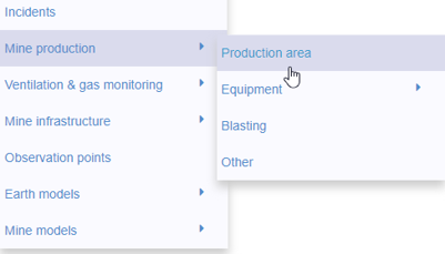
New mine production theme
In Geoscience INTEGRATOR, version 3.2 has a new theme called Production area. It’s designed for stope, mining room, or drawpoint data...

Search for Objects – find anything, anywhere, anytime
In GOCAD Mining Suite find any objects you're looking for in no time...

Rock reclassification editor
In GOCAD Mining Suite, you can simplify logging codes for modelling projects and data management using the Rock reclassification editor...

Copying objects between Workspaces
In Geoscience ANALYST objects can be copied from one Workspace to another by using Ctrl+C and Ctrl+V...

Mira Geoscience Partners with Tessael to Advance Geological Modelling in Geoscience ANALYST
Capture geological observations quickly, safely, and accurately, both in the field and office with HiveMap...