

Geological & Geophysical Consulting Services
We provide specialized mineral exploration and mining consulting services in geological modelling that fully incorporate drillhole, geological mapping, geophysical, geochemical, and geotechnical data to achieve your exploration and geotechnical objectives. Our experts provide a wide spectrum of services such as integrated interpretation, geological model construction, software training, and advisory services. We are the industry leaders in advanced 3D and 4D interpretation and earth modelling, geologically-driven geophysical inversion, exploration targeting, geotechnical hazard assessment, and 4D geoscience data management solutions.
Mineral exploration consulting services
Geological interpretation and 3D modelling
We provide the knowledge and tools for the construction of 3D models and interpretation of complete geological frameworks supported and cross-validated by multiple data sets.
Advanced geophysical interpretation, modelling, and inversion
We provide the knowledge and tools for interpretation and creation of geological models fully consistent with geophysical field data.
Mineral systems interpretation and targeting
We provide the knowledge and tools for the construction of 3D models and interpretation of complete geological frameworks supported and cross-validated by multiple data sets.
Geostatistics and machine learning
We offer solutions and knowledge to properly conduct exploratory data analysis, interpolations, simulations, and enhanced interpretation leveraging the power of machine learning algorithms.
Stratigraphic interpretation and modelling
We provide the knowledge and tools for interpretation and creation of geological models fully consistent with geophysical field data.
4D geotechnical hazard assessment
Our team has the skills and technology to quantitatively forecast geotechnical hazards for design or real-time monitoring.
Please contact our consultants for additional information about our products and services

The value of using structural restoration tools in exploration modelling – Virtual Lecture
Watch recording - Jean-Philippe shows the use of structural restoration tools in GMS as a modelling tool for structurally controlled deposits...

Rock reclassification editor
In GOCAD Mining Suite, you can simplify logging codes for modelling projects and data management using the Rock reclassification editor...

Managing import templates
In Geoscience INTEGRATOR it is possible to edit Import template names and no-data values, activate/deactivate templates, see...

R&D project with UDMN
We have been awarded a major R&D project from the Ultra Deep Mining Network (UDMN) called “4D Real-Time Geotechnical Hazard Assessment and Reporting”.
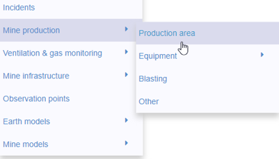
New mine production theme
In Geoscience INTEGRATOR, version 3.2 has a new theme called Production area. It’s designed for stope, mining room, or drawpoint data...

Scripting – Geoscience ANALYST Pro – Virtual Lecture
Past event. Have a look at the video to learn about mathematical and logical scripting in Geoscience ANALYST Pro...

Advanced drillhole planning and monitoring
We partnered with Groupe MISA to develop a low-cost 3D application where all elements of drillhole design and monitoring...

Using ioGAS in Geoscience ANALYST Pro – Virtual Lecture
Past event, recording available here...