


We have quite a few how-to and tutorial videos lined up on YouTube highlighting our earth modelling, interpretation, and data management software for the construction of plausible geological models. There are over 30 videos derived from our monthly tips, trainings, and virtual lectures made available to you whenever you need them!
We also crafted great playlists that showcase recordings of talks, short courses, and workshop we gave throughout the years, or videos from our clients using our 3D software.
If you haven’t had the chance to look at our channel yet, here are some featured videos:
How to use the stereonet application in GOCAD Mining Suite
Using Python in Geoscience ANALYST
UBC MAG3D inversion in 5 minutes
Latest news

Clipping isovalues and sections
In Geoscience ANALYST you can clip isovalues and sections by volume using the free visualization tools to focus on areas of interest in any block model...

DC resistivity inversion in Geoscience ANALYST Pro Geophysics
Past event, view here or via our YouTube channel...

Geological 3D-GIS query
In GOCAD Mining Suite, you can create points at specific geological contacts for the construction of your geological contact surface...

Peak finder – Geoscience ANALYST geoapps: Python application
Past event. Link to recording available here.

Scripting
In Geoscience ANALYST Pro the Script on Object Property utility in Geoscience ANALYST Pro can be used in a wide variety of geoscientific applications...

UDMN Award of Excellence
Geoscience INTEGRATOR wins - Last December, UDMN presented us with an Outstanding Achievement in Commercialization...

K-means clustering: compute inertia curve
In Geoscience ANALYST Pro the K-means clustering utility includes the ability to compute the data’s inertia curve...

Adding reference images
You can add reference images to mine fusion models and hazard reports in Geoscience INTEGRATOR to better orient yourself visually.
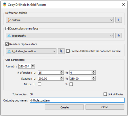
Copying drillholes in a grid pattern
In Geoscience ANALYST you can copy an existing drillhole’s collar and deviation in a grid pattern to map a mineralized horizon...

Drillhole Statistics
In Geoscience ANALYST you can compute drillholes’ deviation statistics. These include...

Editing property’s colormap
In GOCAD Mining Suite, when you select a property its colormap can be edited...

Cloning import templates
In Geoscience INTEGRATOR, cloning an import template provides a ready-to-edit copy without having to build a new one from scratch...