



When you colour your nodes by a classification or binary property in the scatter plots (version 3.5 and up), you can show/hide classes by clicking them in the legend at the bottom. A single-click shows or hides a class. Double-click to show only that class and double-click again to show all classes again.

Previous tips can be found under the Software tip category in the News section and in the Archives section of our website.
Latest news

Customize the Viewport axis labels
In Geoscience ANALYST you can customize the Viewport axis labels
..

Roles and permissions
In Geoscience INTEGRATOR, system administrators give users different levels of permission by role-based access...

New release – Geoscience INTEGRATOR 4.2
Geoscience INTEGRATOR 4.2 unveils a range of new features and improvements designed to boost performance and enhance user experience.

Editing file settings
In Geoscience INTEGRATOR version 3.4, users will be able to edit their files’ settings...

Show and hide
In Geoscience ANALYST you can show and hide everything, individual objects, container groups or drillhole groups...
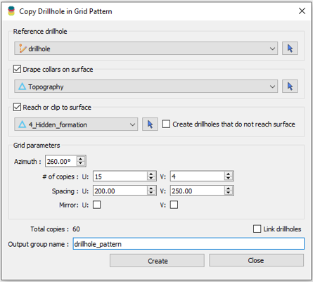
Copying drillholes in a grid pattern
In Geoscience ANALYST you can copy an existing drillhole’s collar and deviation in a grid pattern to map a mineralized horizon...

Pointer Tracking
In GOCAD Mining Suite you can take advantage of the Pointer Tracking view to track coordinates, objects, and properties.

Creating 3D geological starting model from geological maps and structural measurements
In this lecture, Philippe generates a 3D geological model from a map with structural measurements in Geoscience ANALYST...

Automatic rotation
In Geoscience ANALYST you can autorotate viewport when presenting your 3D geoscientific data and models...

Mira Geoscience receives the 2023 AME Innovation Award
John McGaughey, Mira Geoscience's President, has been selected for the 2023 AME Innovation Award for leading the development of GEOH5.

Snapshot grid sections
In GOCAD Mining Suite quickly take snapshots of your Voxet sections using the snapshot tool...

Importing and preparing DC/IP data for inversion with Geoscience ANALYST – Virtual Lecture
In 20 mins, Kristofer shows v3.4 new functionality for pre-processing and visualization of DC/IP 2D and 3D data - Geoscience ANALYST...