
3D Mining Industry Software & Solutions

Browse our catalogue of mining industry solutions featuring integrated, quantitative 3D and 4D earth-modelling software that brings together geological, geophysical, geochemical, and geotechnical tools to create multi-disciplinary models for mineral exploration, geological interpretation, and geotechnical business challenges.

Mining Industry Products

Geoscience INTEGRATOR + Geoscience ANALYST

Integrated 3D platform built for mineral exploration and data management. Together, they provide a seamless environment for managing, visualizing, and interpreting complex geoscience data across disciplines.

Learn more

Geoscience ANALYST

Powerful software solution for visualization, communication, analysis, and integrated interpretation of multi-disciplinary geoscience and mining data and models. Available in four different modules that complement each other, extending the software's technical capabilities.

Learn more

Geoscience INTEGRATOR

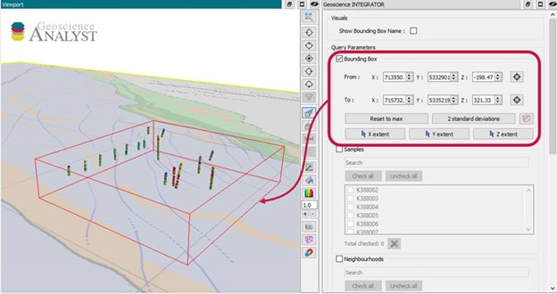
Industry-leading data management system with 3D visualization, query, and analysis capabilities for integration of 3D mineral exploration and 4D geotechnical engineering data, interpretation, models, and metadata.

Learn more

HiveMap

HiveMap helps teams capture high-quality geological data, collaborate in real time, and move more quickly from observation to interpretation—reducing risk, improving confidence, and delivering more effective geological outcomes across projects.

Learn more

GOCAD® Mining Suite

3D geological modelling software for integrated multi-disciplinary 3D modelling. It excels in creating geological models where other software applications struggle. Go beyond implicit modelling to create valid interpretation that honours all your data.

Learn more

DUG Insight

Advanced seismic interpretation software developed by DUG Technology. The platform enables geoscientists to process, visualize, and interpret seismic data within a single integrated environment, helping teams gain clearer insights into subsurface structures and make more informed exploration decisions.

Learn more

UBC-GIF

Industry-standard codes developed by the University of British Columbia Geophysical Inversion Facility, including 3D modelling and inversion programs for gravity and magnetic gradient data, resistivity and induced polarization, and electromagnetics. Sold separately.

Learn more

VP Suite

VP Suite enables powerful 3D geophysical inversion by modeling the Earth as vertical prisms that capture geological domains and their physical properties. This domain-based approach supports complex geology while retaining the flexibility to run fully unconstrained inversions when needed.

Learn more

SimPEG

SimPEG, short for Simulation and Parameter Estimation in Geophysics, is a widely used open-source Python framework designed for modelling and inversion in geophysical applications.

Learn more

Python Integration

Leverage the powerful visualization capabilities of Geoscience ANALYST along with open-source code from the Python ecosystem through the open-source Python API - geoph5py - and the geoapps repository.

Learn more

Please contact our team for additional information about our products and services

Latest news

March, 31 2021

15 tips in 15 minutes

15 Geoscience ANALYST tips on advanced visualization and knowledge sharing...
Read more
Company news
January, 03 2024

25 years modelling the earth together

Dedicated to driving technological innovation and excellence in the realm of geoscience. Your success is at the heart of everything we do.
Read more
Case studies
August, 16 2023

Chasing Innovation from the Ground Up

Advances in geoscience are built on ingenuity. Circé Malo-Lalande knows it too well. Discover more about Canadian Royalties' fascinating success story.
Read more
Software releases
September, 02 2020

A YouTube Channel about 3D modelling

We have quite a few how-to and tutorial videos lined up on YouTube highlighting our earth modelling, interpretation, and data management software for the construction of plausible geological models.
Read more
Geoscience ANALYST
May, 04 2020

Displaying drillholes

Past event, view here or via our YouTube channel...
Read more
Advanced geophysical interpretation, modelling and inversion
November, 03 2021

Deep Learning as an alternative to downward continuation filters for structural interpretation

Jean-Philippe Paiement proposes an alternative approach to the commonly used downward continuation filters used in the industry...
Read more
August, 16 2021

Automatic calculation of XYZ for drillhole sample location

In Geoscience INTEGRATOR, drillhole sample locations are automatically computed as XYZ by the system from the deviation surveys...
Read more
Geoscience INTEGRATOR
December, 07 2020

Footprints project public data repository available soon

Project-generated and previously public data, models, and documents from the NSERC-CMIC mineral exploration project, “Integrated Multi-Parameter Footprints of Ore Systems...
Read more
April, 12 2022

Earth model’s themes are renamed

In Geoscience INTEGRATOR v3.7, the “Earth models” theme group is renamed “Models, maps and sections” and the theme’s names were...
Read more
September, 13 2021

Manual classifications vs Project classifications

In Geoscience INTEGRATOR, There are two ways to create classifications when importing data...
Read more
February, 02 2022

New Visual Parameter – Contours

In Geoscience ANALYST you can visualize contours on 2D grids. Select your data, specify the contour parameters, or change the colour. ..
Read more
September, 01 2022

Drillhole Statistics

In Geoscience ANALYST you can compute drillholes’ deviation statistics. These include...
Read more