Advanced geophysical interpretation, modelling, and inversion

We provide the knowledge and tools for interpretation and creation of geological models fully consistent with geophysical field data.

Geophysical data are best interpreted in tight integration with the geological data. We combine the most practical and effective geophysical forward modelling and inversion, 3D geological modelling, and visualization technology to achieve meaningful, business-focused results. Our team has been at the forefront of the development and implementation of quantitative modelling and inversion across the range of geophysical methods. We understand the complexity of the issues and the need for practical, geologically-driven solutions. We work collaboratively with clients to provide dependable advice and maximum interpretational value.

Our team works across the complete spectrum of geophysical techniques. We provide analytical and interpretational value in ore body detectability analysis, survey design, geologically-constrained inversion, 3D geological modelling, integrated interpretation, drillhole targeting, contract geophysical research, and geophysical software development.

Related products

“Owing to the success of the 3D inversion initiative carried out over the immediate Tulsequah Chief deposit area, the Company is again retaining Mira Geoscience Ltd. (“Mira”) to perform 3D inversions of IP data over the very prospective Big Bull, Banker/Sparling and southeast areas of the Tulsequah VMS property.”

Chieftain Metals Inc.Toronto, Canada

Related resources

Geoscience INTEGRATOR
December, 07 2020

Free mineral exploration data through Geoscience ANALYST

Past event - view here or on our YouTube channel...
Read more
Geoscience ANALYST
April, 07 2026

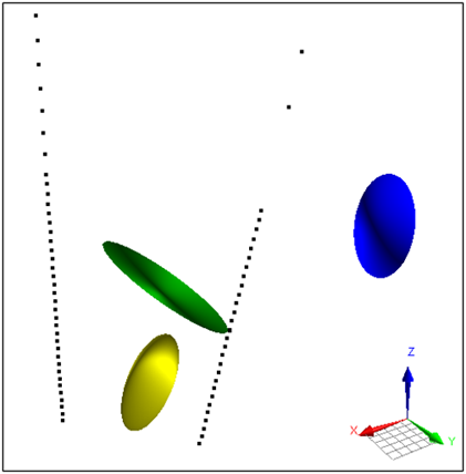
Parametric Ellipsoid Modelling in Geoscience ANALYST Pro Geophysics

A Fast New Way to Interpret TEM Anomalies. Read more >>
Read more
Geoscience ANALYST
April, 22 2020

Constrained inversion using GRAV3D

Past event, view here or via our YouTube channel...
Read more
June, 18 2022

Filter records with, or without files associated to them

Geoscience INTEGRATOR offers the convenience of associating files to data records to...
Read more
Geoscience ANALYST
July, 08 2021

Using ioGAS in Geoscience ANALYST Pro – Virtual Lecture

Past event, recording available here...
Read more
Developer’s sandbox
June, 08 2020

Advanced drillhole planning and monitoring

We partnered with Groupe MISA to develop a low-cost 3D application where all elements of drillhole design and monitoring...
Read more
February, 10 2021

Property value range

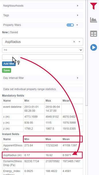
In Geoscience INTEGRATOR, You can refer to the range of values in the query panel to apply numeric property filters...
Read more
Company news
January, 04 2024

Meet Polyanna Rowe, PhD

This release includes enhancements to several existing importers and exporters for extended interoperability, and more...
Read more

Advanced processing, modelling, and inversion

We use the industry’s best available software to create fully integrated earth models of any complexity. We use a broad range of geophysical data processing, modelling, and inversion tools, including UBC-GIF and VPmg forward modelling and inversion codes, Profile Analyst, Maxwell, WinDisp, and Paradigm’s seismic modelling and interpretation software. Mira Geoscience’s GOCAD/SKUA-based geophysical modules provide a wide range of geophysical utilities and flexible workflow interfaces for the set up and execution of forward modelling and geologically-constrained inversion, including the pre-processing of data and the post-processing of the results.

Geological interpretation, petrophysical properties, and geophysical data must support a single geological model. Our structural, formational, and facies modelling software tools ensure that 3D geological models respect a consistent structural, stratigraphic, and topological framework in addition to ensuring consistency between the geological models and geophysical data. We work with an extensive set of 3D-GIS, exploratory data analysis, and visualization tools to ensure data integrity and enhance interpretational insight. We provide results in common 3D formats for the easy communication of ideas.

Data sets we work with

Mira Geoscience ensures fast, intuitive, and accurate 3D earth models, regardless of your data types. We work with geological, geophysical, geochemical, and geotechnical data from different mining industry formats: ArcGIS, MapInfo, AutoCAD, GOCAD/SKUA, Gemcom, Surpac, CAE Studio, Vulcan, Geosoft, Leapfrog, ER Mapper, ioGAS, UBC-GIF, VPmg, Profile Analyst, Maxwell, and others.

Our team of experts

With 20 years of experience and thousands complex projects completed, we know the best practices for modelling and interpreting challenging geophysical data sets. We are specialists in finding innovative ways to increase value, reduce the limitations, and understand the meaning of geophysical data. Analyzing data sets within a proper geology-geophysics integration framework has proved repeatedly to be a cost-effective way of adding value to projects. We will host meetings anywhere for project review, interpretation, or investment purposes.

Our team of experts

Please contact our team for additional information about our products and services