


The newest version of Geoscience INTEGRATOR introduces powerful new functionality to streamline workflows and improve usability
Key new features:
-
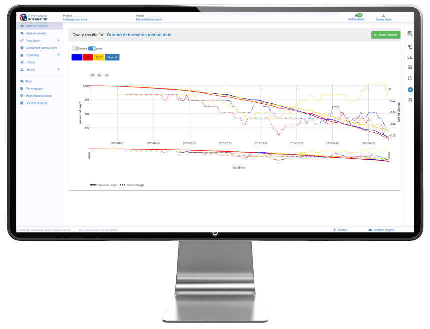
Display multiple stations and Y-axis values in time series charts, distinguished by colour and pattern.
-
Refresh the design of the Data set explorer, Import history, and Project settings pages.
-
Overwrite collar locations or replace drillhole paths directly from CSV files, with automatic updates via Monitoring folders, without the need to delete and re-import data.
Please note that Geoscience INTEGRATOR 4.2 is compatible with Geoscience ANALYST 4.6. Previous versions of Geoscience ANALYST will not be compatible with this release.
Is this your first time working with Geoscience INTEGRATOR?
Visit our YouTube channel, or check out the Resources tab on our website for tips and tutorials. You can also sign up for our email newsletter or join our community on LinkedIn to stay abreast of the latest news.
Please contact our team for additional information about our products and services
Latest news

New release – Geoscience ANALYST 4.6
Geoscience ANALYST 4.6 brings performance improvements and key new features to all modules. Download it now!

Revolutionizing Subsurface Interpretation and 3D Visualization with Geoscience ANALYST Pro
Discover how EnBW is bridging the gap between 2D mapping, 3D seismic interpretation, and integrated geophysical workflows

GEOH5: A Framework for Geoscience Data and Model Portability
Used by thousands, GEOH5 is the open-source data structure that is taking down the interoperability barriers and revolutionizing...

John McGaughey receives the Grahame Sands Award
John McGaughey, President of Mira Geoscience, receives ASEG's 2024 Grahame Sands Award for a career dedicated to innovation in applied geophysics.

Coordinate display area
In Geoscience ANALYST you can get real-time feedback on the XYZ coordinates corresponding to the...
..

Deep Learning as an alternative to downward continuation filters for structural interpretation
Jean-Philippe Paiement proposes an alternative approach to the commonly used downward continuation filters used in the industry...

Customizing metadata
Version 3.0 of Geoscience INTEGRATOR has a new layout for data set summaries that allows you to document any general information as custom...

Upload global descriptions
In Geoscience INTEGRATOR, add an editable global description during import to save time and reduce errors...

Chasing Innovation from the Ground Up
Advances in geoscience are built on ingenuity. Circé Malo-Lalande knows it too well. Discover more about Canadian Royalties' fascinating success story.
Automatic calculation of XYZ for drillhole sample location
In Geoscience INTEGRATOR, drillhole sample locations are automatically computed as XYZ by the system from the deviation surveys...

15 tips in 15 minutes – Geoscience ANALYST Free Viewer
Past event, view here or on our YouTube channel...

Visualize 3D vector properties
In GOCAD Mining Suite the normal of a surface is an example of a 3D vectorial property, where the components of the vector are...