


With Geoscience INTEGRATOR version 3.5, uploading files, maps, plans, and sections is easier and faster than ever. Not only can you upload up to 100 at a time, but it is also possible to add an editable global description to each, saving time and reducing errors.

Previous tips can be found under the Software tip category in the News section and in the Archives section of our website.
Latest news

Data set summaries
In Geoscience INTEGRATOR The Data set explorer provides simple, immediate ‘dashboard’ access to all the data sets, and their summary information...
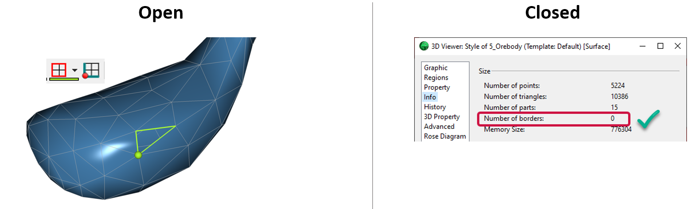
Is the surface opened or closed?
In GOCAD Mining Suite you can easily know if your surface is opened or closed by...

Effective date field
Geoscience INTEGRATOR v3.7 offers the Effective date upload field for files and maps...

Drillhole Statistics
In Geoscience ANALYST you can compute drillholes’ deviation statistics. These include...

Using predictive modelling in mineral exploration
We carried out targeting work for IOCG-style mineralisation in the Mt Dore area of QLD, Australia. We produced a 3D model and predictive exploration map...

Importing and visualizing VP Geophysics models
In Geoscience ANALYST v3.1, VP Model objects can now be imported by a simple drag and drop! You can then visualize the model and,...

K-means clustering
In Geoscience ANALYST Pro’s v3.3, you can quickly partition your data based on the K-means clustering...

Monitoring folders
Geoscience INTEGRATOR's monitoring folders can be used to automatically import files to a project to save time and streamline regular updates.

HiveMap Digital Mapping Software
Safety is always the number one priority on every job and work site. Whether in underground, open pit, or civil engineering settings, our most important job is to make sure…

Quick selection search tool
In Geoscience INTEGRATOR we added a search box to help you find objects lists such as drillholes, samples, or stations that often have thousands of items...

Automatic rotation
In Geoscience ANALYST you can autorotate viewport when presenting your 3D geoscientific data and models...

Dynamically turn on/off classes in scatter plots
In Geoscience INTEGRATOR, you can turn on/off classes in scatter plots...