



When working with Geoscience ANALYST Pro, its Python API, and geoapps, you can enable a monitoring directory to instantly visualize and analyze the results. Simply go to File > Enable Monitoring Directory and choose the same folder that the Python API and geoapps are writing results to.

To see this Python API and live link in action, check out this YouTube video.
Previous tips can be found under the Software tip category in our News page and in our Archives page. Join our Virtual Lecture series that showcases technological advancements and provides quick tutorials on Geoscience ANALYST features. More details about this series on our Events page or sign-up to the mailing list.
Latest news

R&D project with UDMN
We have been awarded a major R&D project from the Ultra Deep Mining Network (UDMN) called “4D Real-Time Geotechnical Hazard Assessment and Reporting”.
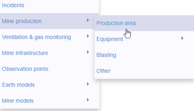
New mine production theme
In Geoscience INTEGRATOR, version 3.2 has a new theme called Production area. It’s designed for stope, mining room, or drawpoint data...

3D seismic data and survey designer tools
Coming soon to Geoscience ANALYST, tools for hard rock seismic...

Organizing files as data sets
In Geoscience INTEGRATOR, a data set is often composed of a group of files of various formats along with metadata. These can be grouped...

Drape Voxet properties on surfaces
In GOCAD Mining Suite you can texturally drape your images and 2D gridded data onto surfaces, for example...

Georeference images
In Geoscience ANALYST Pro you can georeference your geology maps and cross sections with...

New release – Geoscience INTEGRATOR 3.9
This version includes new functionality to provide a better user experience, such as: user notifications, new display options, and more!

Customizing metadata
Version 3.0 of Geoscience INTEGRATOR has a new layout for data set summaries that allows you to document any general information as custom...

Arbitrary sections
In Geoscience ANALYST visualize your block model in any direction with the new arbitrary section