Geoscience ANALYST 3D Viewer

FREE visualization and communication software for integrated, multi-disciplinary geoscience and mining data and models.

Geoscience ANALYST 3D viewer is a free standalone application that allows you to import, visualize, annotate, save, and distribute a multitude of 3D geoscience and mining data and models.

Share and communicate your geoscience data, 3D models, metadata, and interpretation with your colleagues and stakeholders effortlessly to make informed, data-driven decisions.

Why should you try it?

  • Its intuitive and modern user interface enables the rapid understanding of complex data.
  • You can import and share numerous data (e.g., structural, geological, geochemical, seismic, grav/mag, EM, DC/IP, drillholes) and model formats, including GOCAD Mining Suite and VP Suite.
  • Its open GEOH5 file format allows you to store and share your projects in a documented public, open, easy-to-use, vendor-neutral, and permanently accessible data exchange and storage format.
  • Its open-source geoh5py Python API and geoapps application repository allow you to leverage the powerful visualization capabilities of Geoscience ANALYST along with open-source code from the Python ecosystem.

This software is great. It accomplishes all the aspects I need to be able to spend more time evaluating and thinking about exploration project data, not fussing over complex software. I have advised a number of exploration colleagues to get going on this software; it continues to be fantastic.

Todd KeastP.Geo Consulting Geologist

Key Product Features

Visualization

The free Geoscience ANALYST 3D viewer provides a high-performance 3D environment for viewing and exploring integrated geological, geophysical, geochemical, geotechnical, and other geoscientific datasets. Users can interactively visualize large-scale models, drillholes, voxel data, and surfaces with customizable display settings, dynamic slicing tools, and linked 2D/3D views for comprehensive spatial understanding and interpretation.

Communication

Geoscience ANALYST 3D viewer streamlines collaboration, allowing you to make annotations, save views, and export high-quality visuals. Projects can be exported to the open GEOH5 format, allowing users to compile all data and metadata—including reports, images, and interpretations—into a single, portable file. This file can be opened for free by any stakeholder, using Geoscience ANALYST 3D viewer. This ensures seamless handoffs, long-term data integrity, and compatibility with open-source geoscience tools.

Import

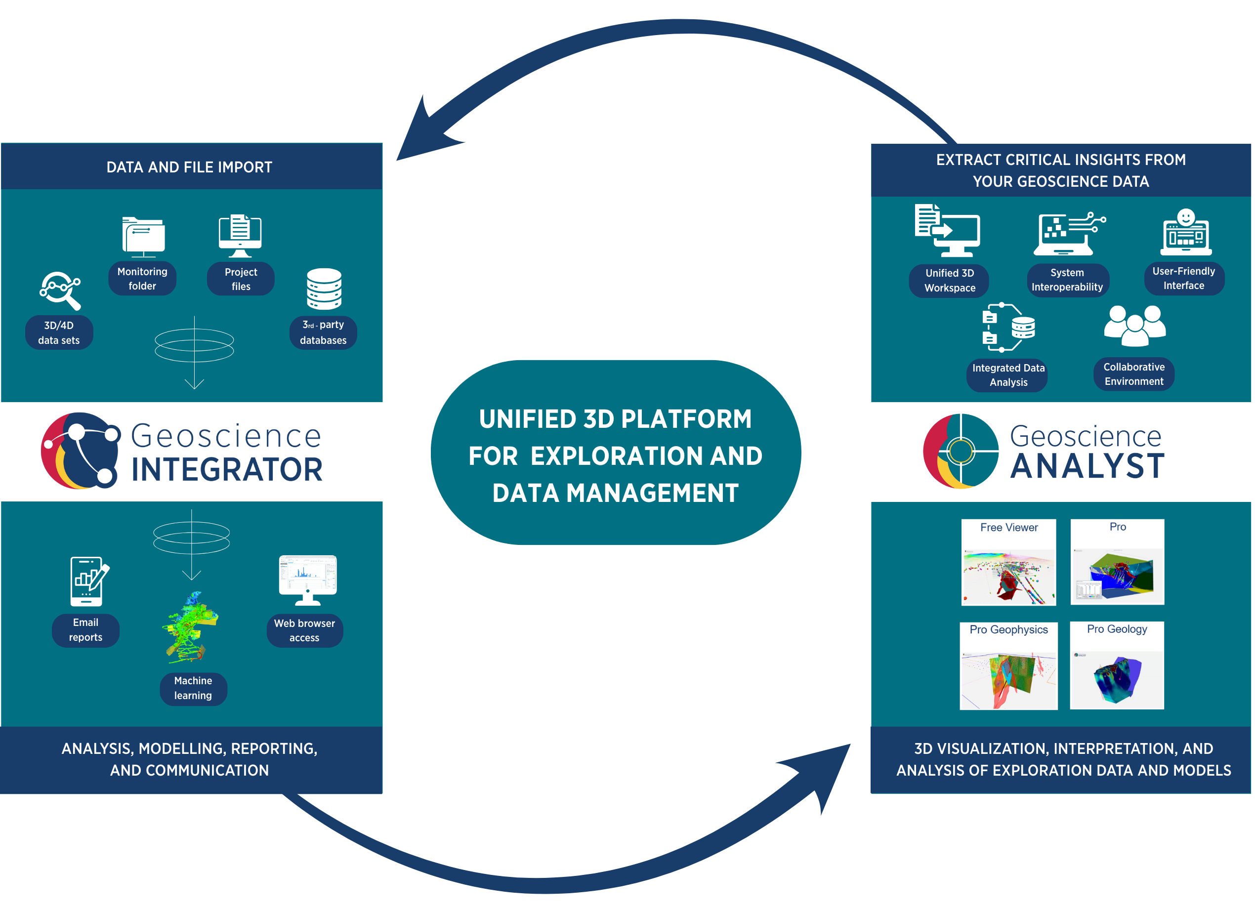
Supports a wide range of industry-standard formats, allowing seamless import of drillholes, grids, models, and point data. Users can quickly drag and drop files, define coordinate systems, and retain metadata, ensuring that all data is accurately georeferenced and ready for analysis.

Connectivity

Geoscience ANALYST connects with both proprietary and open-source tools, enabling integrated workflows with platforms like Geoscience INTEGRATOR, GOCAD Mining Suite, and Python.

Explore Additional Product Options

Pro

Geoscience ANALYST Pro offers additional functionality for object creation, editing, data processing, interpretation, and targeting.

Pro Geophysics

Geoscience ANALYST Pro Geophysics offers advanced, yet easy-to-use, geologically-constrained geophysical interpretation.

Pro Geology

Geoscience ANALYST Pro Geology provides an enriched geologist’s toolkit, including AI methods for geological interpretation.

Are you using our software and have questions?

Visit our FAQs

For tips, tutorials and how to videos

Visit our YouTube channel

Latest news

Geoscience ANALYST
February, 11 2021

15 tips in 15 minutes – Geoscience ANALYST Free Viewer

Past event, view here or on our YouTube channel...
Read more
Geoscience INTEGRATOR
December, 07 2020

Free mineral exploration data through Geoscience ANALYST

Past event - view here or on our YouTube channel...
Read more
Developer’s sandbox
September, 08 2023

GEOH5: A Framework for Geoscience Data and Model Portability

Used by thousands, GEOH5 is the open-source data structure that is taking down the interoperability barriers and revolutionizing...
Read more
Geoscience ANALYST
July, 29 2020

Getting started with the Python geoh5py

Past event, view here or via our YouTube channel...
Read more
Geoscience ANALYST
September, 23 2021

Including water bodies in gravity and magnetic inversion modelling – Geoscience ANALYST Pro Geophysics

Thomas Campagne demonstrated how to explicitly include bathymetry in inversion modelling of near-shore gravity data...
Read more
February, 02 2022

New Visual Parameter – Contours

In Geoscience ANALYST you can visualize contours on 2D grids. Select your data, specify the contour parameters, or change the colour. ..
Read more
January, 17 2022

No-data values on import templates

In Geoscience INTEGRATOR, you can prevent importing no-data value strings by providing a general NDV to be applied to all properties of the template...
Read more
Geoscience ANALYST
February, 17 2020

Bridging the gap

Industry uptake of academic exploration and mining research is often slower than it should be. Academics must focus on innovation and education...
Read more
July, 15 2019

Extracting property names from a CSV

In Geoscience INTEGRATOR, extract the property names directly from a CSV file to speed up the process and reduce errors...
Read more
August, 10 2020

Importing and visualizing VP Geophysics models

In Geoscience ANALYST v3.1, VP Model objects can now be imported by a simple drag and drop! You can then visualize the model and,...
Read more
March, 01 2019

Create array property from scalar properties

This command, found in GOCAD's Property menu, creates a multi-dimensional array property from user-selected properties...
Read more
March, 16 2020

View neighbourhoods in 3D

You can display your neighbourhoods in Geoscience INTEGRATOR 3D viewer, making it easier to understand spatial distribution of the data.
Read more

Please contact our team for additional information about our products and services