


When querying for samples, you can filter them according to the drillhole they are located in. You can select multiple drillholes and the query will return all the samples associated to them.

Note that using both the Samples and the Drillholes & wells filters together will return samples that fit both.
Previous tips can be found under the Software tip category in the News section and in the Archives section of our website.

Latest news

Pointer Tracking
In GOCAD Mining Suite you can take advantage of the Pointer Tracking view to track coordinates, objects, and properties.

Improved data analysis
Analyze your data with enhanced histogram display options available in GOCAD Mining Suite v19...

25 years modelling the earth together
Dedicated to driving technological innovation and excellence in the realm of geoscience. Your success is at the heart of everything we do.

Footprints project public data repository available soon
Project-generated and previously public data, models, and documents from the NSERC-CMIC mineral exploration project, “Integrated Multi-Parameter Footprints of Ore Systems...

Québec Mining 2024
Explore the full interview that Scott Napier did for Québec Mining 2024


Women Geoscientists in Canada
We are proud sponsors of WGC, advocates for increased gender balance within geosciences...

ODBC drillhole import
In Geoscience ANALYST you can import drillholes straight from your ODBC database...
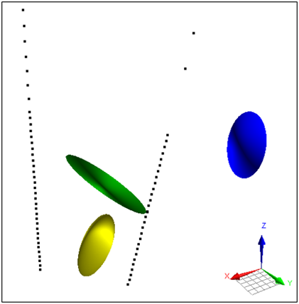
Parametric Ellipsoid Modelling in Geoscience ANALYST Pro Geophysics
A Fast New Way to Interpret TEM Anomalies. Read more >>

BHP Bowen Basin, Australia
Surface electromagnetic and electrical methods were trialled at a mine in the Bowen Basin, Queensland, with the objective of mapping the extent of coked coal...

Block model volume
In Geoscience ANALYST you can visualize your block model data by volume in the Visual Parameters panel...
..

DC resistivity inversion in Geoscience ANALYST Pro Geophysics
Past event, view here or via our YouTube channel...