


In Pro version 4.0, you can apply coordinate system transformations to Points, Curves, Surfaces, and 2D Grid objects, from current to targeted Coordinate Reference System.
Utilities menu > Coordinate System Transformation > Geodetic tab

If upon import your raster data already contained coordinate system information, this is saved in the object’s metadata.
Otherwise, all other object’s coordinate systems are set as unknown and can be defined.

Previous tips can be found under the Software tip category in our Resources page and in our Archives page.
Latest news

Taskbar icons
In GOCAD Mining Suite, icons are added to the taskbar when you open windows such as another 3D Viewer or the 3D-GIS Query panel...

K-means clustering: compute inertia curve
In Geoscience ANALYST Pro the K-means clustering utility includes the ability to compute the data’s inertia curve...

Colouring histograms
In GOCAD, you can colour your histogram by object, region or property...

GEOH5: A Framework for Geoscience Data and Model Portability
Used by thousands, GEOH5 is the open-source data structure that is taking down the interoperability barriers and revolutionizing...

Drag-and-drop files into a 3D compilation
In Geoscience ANALYST, you can create a 3D compilation by simply dragging your data right into the Viewport...
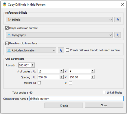
Copying drillholes in a grid pattern
In Geoscience ANALYST you can copy an existing drillhole’s collar and deviation in a grid pattern to map a mineralized horizon...

Georeference images
In Geoscience ANALYST Pro you can georeference your geology maps and cross sections with...

ERO Copper Curaçá Valley, Brazil
Maximizing value: 3D data integration and interpretation. One of the main challenges in exploration is increasing our subsurface knowledge...

Using predictive modelling in mineral exploration
We carried out targeting work for IOCG-style mineralisation in the Mt Dore area of QLD, Australia. We produced a 3D model and predictive exploration map...

Viewing data from report items
In Geoscience INTEGRATOR table and chart items from ad-hoc or scheduled reports can be easily refreshed, using the same filters that were applied in the original report, to display current data.

Effective date field
Geoscience INTEGRATOR v3.7 offers the Effective date upload field for files and maps...

Scripting – Geoscience ANALYST Pro – Virtual Lecture
Past event. Have a look at the video to learn about mathematical and logical scripting in Geoscience ANALYST Pro...