


Using 3D modelling to avoid ore dilution
In coal mining it is important to know if localized areas of coal have been rendered worthless through contact metamorphism adjacent to volcanic dykes or sills. This high temperature metamorphic process results in “coked” or “cindered” coal, which is graphitised and is highly electrically conductive. Coked coal should be excluded from the ore reserve model and is ideally discarded during the mining process. To avoid dilution of high-quality coal with waste, accurate coked coal boundaries are traditionally mapped by expensive drilling prior to mine planning.
Case study: Bowen Basin mine site, Queensland
Surface electromagnetic and electrical methods were trialled at a mine in the Bowen Basin, Queensland, with the objective of mapping the extent of coked coal. The methods trialled included moving-loop time-domain electromagnetics (MLTEM), Sub-Audio Magnetics (SAM), and conventional direct-current resistivity/induced polarization (DCIP).
MLTEM was found to be an effective tool for mapping the coked coal. Figure 1 below shows a one-dimensional (1D) inversion using the UBC code EM1DTM. The strong flat-lying conductor on the southern two-thirds of the line is associated with coked coal (KC). The dipping feature on the northern third of the line is a 1D inversion artifact. The artifact arises because the measured data are 3D, due to the abrupt edge of the conductor two thirds of the way along the section, whereas the 1D inversion assumes that the earth is horizontally stratified.

Figure 1 One-dimensional inversion results from one of the MLEM survey lines (no vertical exaggeration). The strong flat-lying conductor on the southern two-thirds of the line is associated with coked coal (KC). The dipping feature on the northern third of the line is a 1D inversion artifact.
SAM total field electromagnetic (TFEM) data was also acquired, using a grounded wire transmitter. 3D inversion of TFEM data was feasible because only a single transmitter was employed – the computation time for electromagnetic inversions scales with the number of transmitters. The 3D TFEM inversion used the MLEM 1D inversion result as a reference model. Figure 2 shows a cross-section through the 3D TFEM model, on the closest section to that shown in Figure 1. The extent of the coked coal has been well mapped by the TFEM, and the 3D inversion has greatly suppressed the dipping artifact from the 1D inversion.

Figure 2 Conductivity section through the grounded-source TFEM 3D inversion. The closest corresponding MLTEM 1D inversion is shown in Figure 1. The constrained 3D TFEM inversion has greatly supressed the 1D inversion artifact.
Although this case study applies to coal mining, the 3D modelling approaches described are applicable in general to SAM, total field electromagnetic and TEM data. We can model data acquired for base metals and gold exploration using similar techniques.
The results of this work have been published at the 2nd Australian Exploration Geoscience Conference by Lowe et al (2019), and can be downloaded from here. We would like to thank our co-authors Jonathan Lowe (BHP), Eric Battig and Dan Eremenco (GAP Geophysics). Permission to show these results was kindly granted by BHP.

James Reid is the Director of our Asia-Pacific consulting services and a Principal Consultant with an extensive geophysical consulting background. He has extensive expertise in the planning and quantitative interpretation of electromagnetic and electrical methods, particularly the application of airborne electromagnetics to mineral and groundwater exploration. He has an MSc in geophysics from the University of Sydney and a PhD in geophysics from Macquarie University. James is based in Perth.

Scott Napier is our Global Director, Consulting and a Principal Geophysicist who brings general expertise in geophysical inversion, along with extensive borehole, ground, marine, and airborne EM interpretation and processing experience. He has worked in Canada and internationally on oil and gas, uranium, and base metal exploration teams, with a track record of proven discovery. Scott has an MSc in geophysics from UBC. Scott is based in Vancouver.
Latest news

Coal industry solutions

Darlot Gold Mine Area, Australia

ERO Copper Curaçá Valley, Brazil

Machine learning in mineral exploration

Simple unconstrained inversion
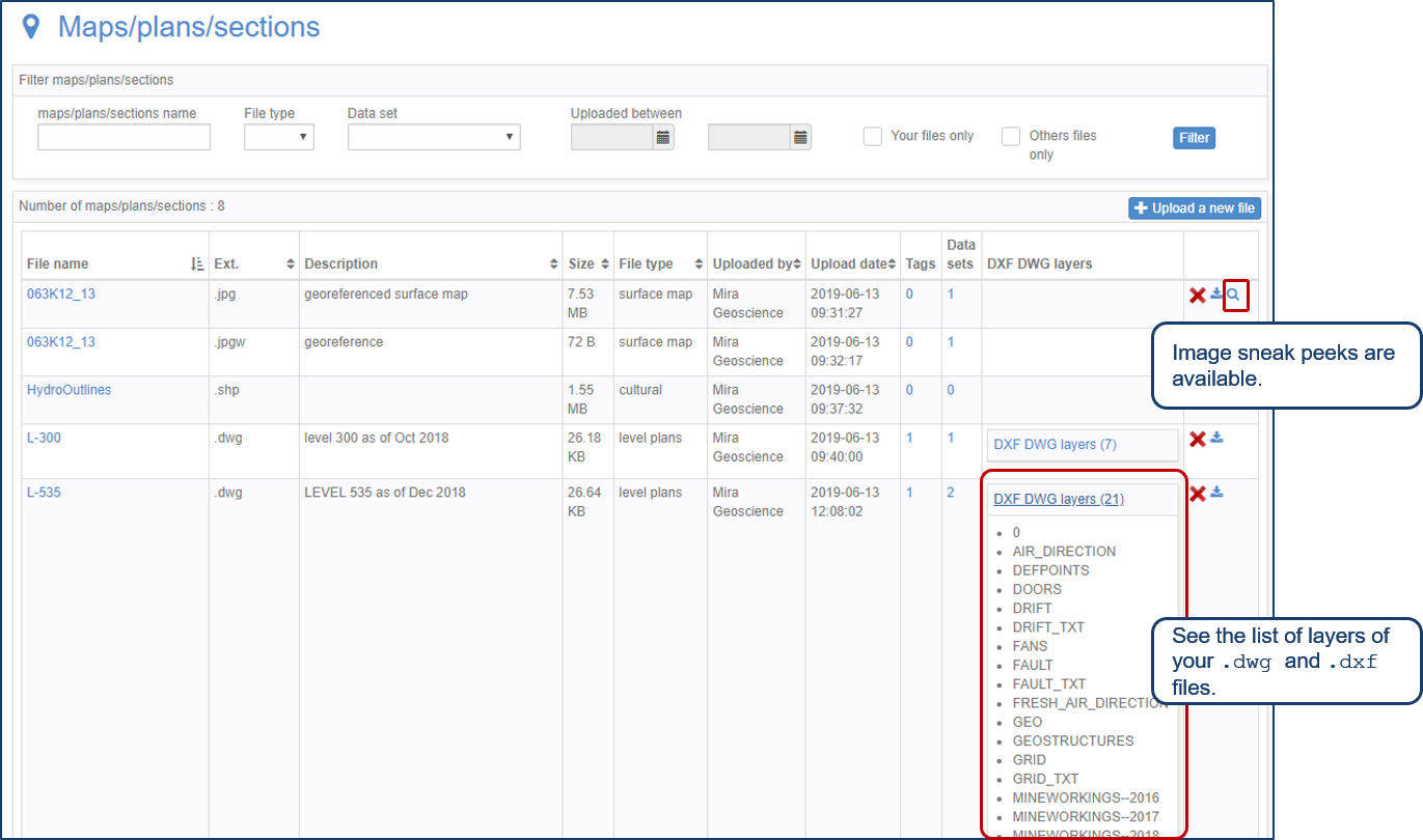
Preview files in the Maps/plans/sections page

Case Study: Gold Fields Cave Rocks, Australia

Editing property settings: Display template

Object’s history

Linking viewports

