


In version 3.4, you can import and visualize your 2D SEG-Y seismic lines. This video will walk you through the import and visualization process, as well as how to drape the section onto a topography surface.

Previous tips can be found under the Software tip category in our News page and in our Archives page.
Latest news

Linking viewports
In Geoscience ANALYST you can synchronize the perspective of all visible Viewports to zoom, pan, and rotate them all at once...
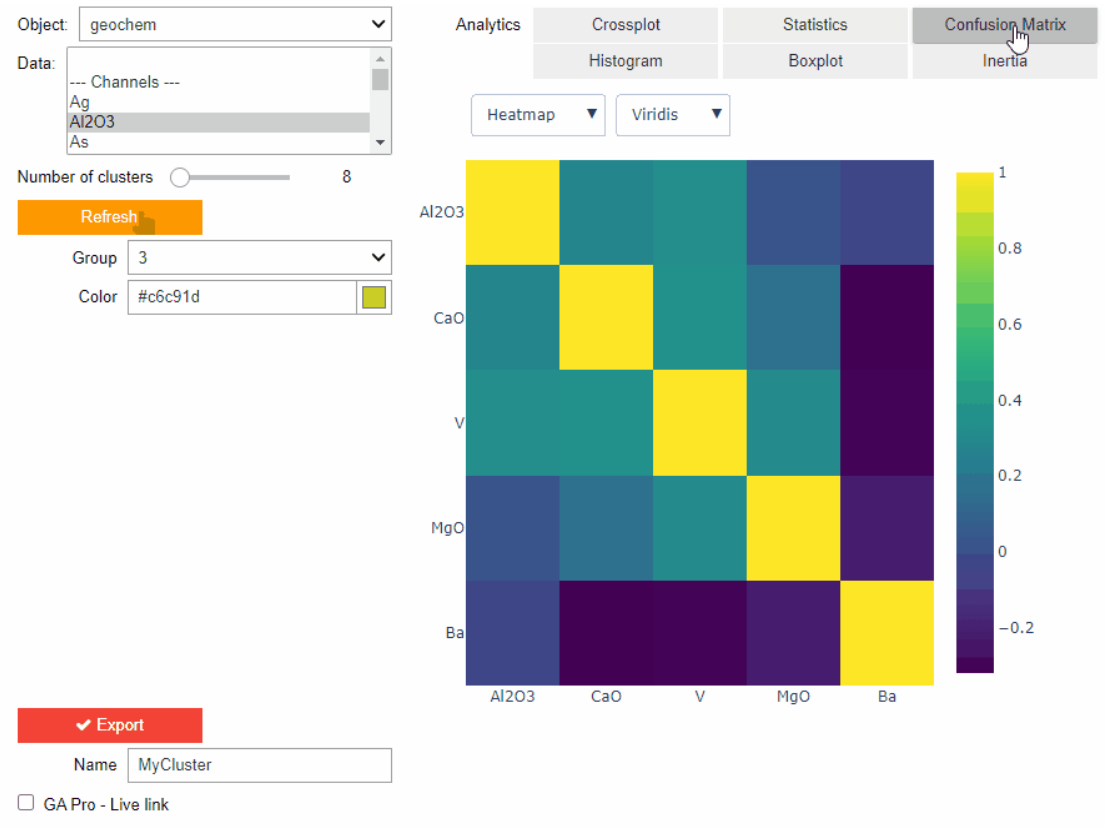
Clustering data stored on geoh5 objects
Past event. View here or on our YouTube channel...
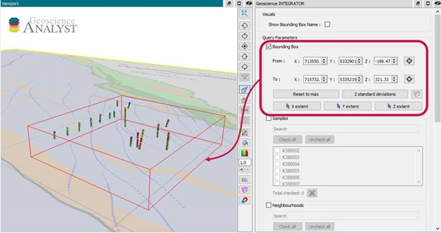
Automatic calculation of XYZ for drillhole sample location
In Geoscience INTEGRATOR, drillhole sample locations are automatically computed as XYZ by the system from the deviation surveys...

Rapid and accurate mapping
We explain how automated generation of alteration maps using radiometric data is well-suited to large-footprint mineral systems...

Customize the Viewport axis labels
In Geoscience ANALYST you can customize the Viewport axis labels
..

Taskbar icons
In GOCAD Mining Suite, icons are added to the taskbar when you open windows such as another 3D Viewer or the 3D-GIS Query panel...

Creating properties within the script editor
In GOCAD, properties can be created within the Property Script Editor by typing the new property name in the script and then clicking Define Variables…

Python API live link
In Geoscience ANALYST you can enable a monitoring directory to instantly visualize and analyze the results...

Peak finder – Geoscience ANALYST geoapps: Python application
Past event. Link to recording available here.

Used v/s available themes
In Geoscience INTEGRATOR, the Theme drop down menu shows a filtered list of those containing data sets by default...

Documents linked to a project
When documents are linked to a project in Geoscience INTEGRATOR, it is possible to be more specific and link them to the project’s data sets...

Q&A: Revival Gold Inc.
We discussed Mira Geoscience’s contribution to further understand the Beartrack-Arnett gold project area using modern exploration techniques...