
Virtual Lecture series – Coffee break… and learn!
Like this video? Go to our YouTube Channel for more!

In this video, Kristofer Davis shows how easy it is to run a geologically-constrained UBC-GIF inversion of potential-field data in Geoscience ANALYST Pro Geophysics.

In 15 minutes he shows how to:

  • Load magnetic data, topography, and a block model from a geologic modelling package (GOCAD Mining Suite, Datamine, Leapfrog, etc.)
  • Attribute with density values and forward model to test the initial geological model
  • Set up the sensitivity and run an unconstrained inversion
  • Run a constrained inversion using a reference model
  • Run a constrained inversion using weights from geologic boundaries

The series will be delivered via Webinars by our Scientific Programmers and will become available on demand after via our YouTube channel. More details about this series on our Events page or join the mailing list.

Kristofer is a Scientific Programmer who completed his PhD in Geophysics at the Colorado School of Mines. At UBC he worked on several advanced problems in geophysical inversion, focusing on development of software workflows to support constrained geophysical inversion. His industry and academic background provide the ideal experience to continue development of our VP Suite products, GIFtools, and our other geophysical tools and workflows. Kristofer is based in Vancouver.

Latest events and news

Conferences
December, 24 2025

Attending AME Roundup 2026?

Visit us at booth 416 to see our software solutions in action and discuss your needs with our expert team!
Read more
Geoscience ANALYST
April, 07 2026

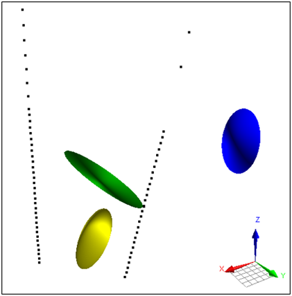
Parametric Ellipsoid Modelling in Geoscience ANALYST Pro Geophysics

We are evolving the way we organize and share our technical content to better support your needs.
Read more
Geoscience ANALYST
June, 22 2021

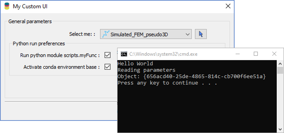
Using Python in Geoscience ANALYST Pro – Virtual Lecture

Past event, link available here...
Read more
August, 03 2020

Have you Scene this?

In GOCAD Mining Suite v19, you can save the view as a Scene by right-clicking on the 3D Viewer > (Scene) Save As…
Read more
How-to videos
January, 24 2022

Creating 3D geological starting model from geological maps and structural measurements

In this lecture, Philippe generates a 3D geological model from a map with structural measurements in Geoscience ANALYST...
Read more
September, 01 2022

Drillhole Statistics

In Geoscience ANALYST you can compute drillholes’ deviation statistics. These include...
Read more
January, 05 2021

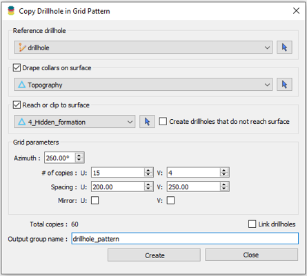
Copying drillholes in a grid pattern

In Geoscience ANALYST you can copy an existing drillhole’s collar and deviation in a grid pattern to map a mineralized horizon...
Read more
Case studies
March, 29 2015

Using predictive modelling in mineral exploration

We carried out targeting work for IOCG-style mineralisation in the Mt Dore area of QLD, Australia. We produced a 3D model and predictive exploration map...
Read more
March, 09 2021

Improved scatter plots

In Geoscience INTEGRATOR, you can can increase/decrease the node size, take snapshots, zoom in on an area of interest...
Read more
Company news
October, 03 2024

Québec Mining 2024

Explore the full interview that Scott Napier did for Québec Mining 2024
Read more
Software releases
October, 14 2025

New release – Geoscience INTEGRATOR 4.2

Geoscience INTEGRATOR 4.2 unveils a range of new features and improvements designed to boost performance and enhance user experience.
Read more
Geoscience ANALYST
May, 13 2021

Scripting – Geoscience ANALYST Pro – Virtual Lecture

Past event. Have a look at the video to learn about mathematical and logical scripting in Geoscience ANALYST Pro...
Read more

Please contact our team for additional information about our products and services