


Geoscience INTEGRATOR v3.5 and Geoscience ANALYST v3.2 include new themes and renamed ones to help you to locate data in a more intuitive way.
- New themes available:
- Targets
- Anomalies
- Geophysics – Inversions
- Topography
- Culture
- Claims, boundaries.
- Several themes have been renamed:
- “Mine model – Underground” is now “Fusion models”
- “Mine infrastructure – Surfaces” is now “Mine infrastructure”
- “Drillholes” is now “Drillholes and wells”
- “Remote sensing” is now “Remote sensing & air photos”
- “Geotechnical monitoring” is now “Geotechnical”.

Previous tips can be found under the Software tip category in the News section and in the Archives section of our website.
Latest news
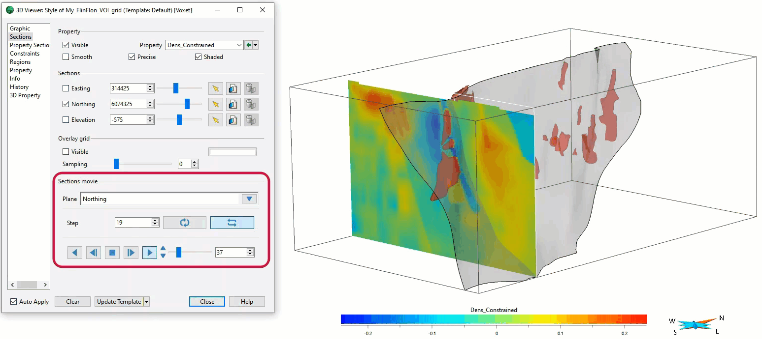
Sections movies
In GOCAD Mining Suite, you can create a section animation by specifying which section plane you want to visualize...

Importing and preparing DC/IP data for inversion with Geoscience ANALYST – Virtual Lecture
In 20 mins, Kristofer shows v3.4 new functionality for pre-processing and visualization of DC/IP 2D and 3D data - Geoscience ANALYST...
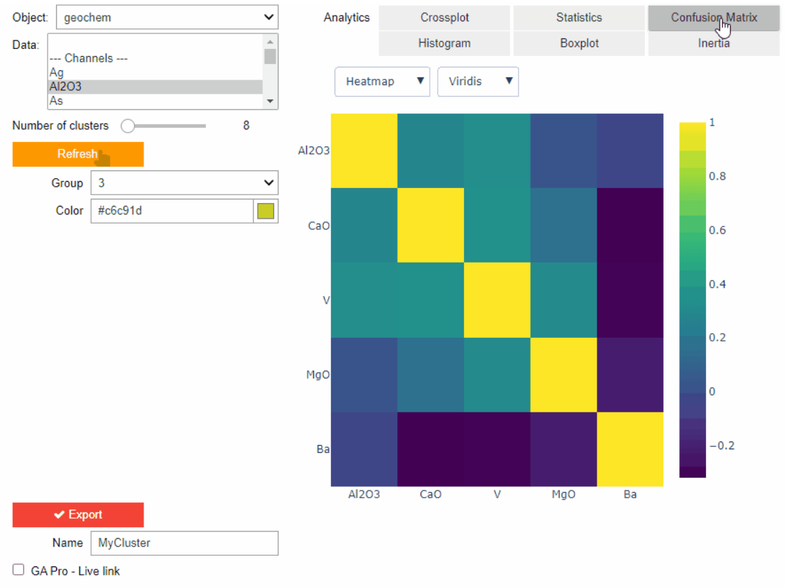
Clustering data stored on geoh5 objects
Past event. View here or on our YouTube channel...

Show and hide
In Geoscience ANALYST you can show and hide everything, individual objects, container groups or drillhole groups...

ERO Copper Curaçá Valley, Brazil
Maximizing value: 3D data integration and interpretation. One of the main challenges in exploration is increasing our subsurface knowledge...

Case Study: Gold Fields Cave Rocks, Australia
An interactive approach to forward modelling and inversion. Exploration is becoming harder, with greater...

3D drillhole design and monitoring in Geoscience ANALYST Pro v4.0 – Virtual Lecture
Jennifer shows the new and updated drillhole design and monitoring tools in Geoscience ANALYST 4.0...
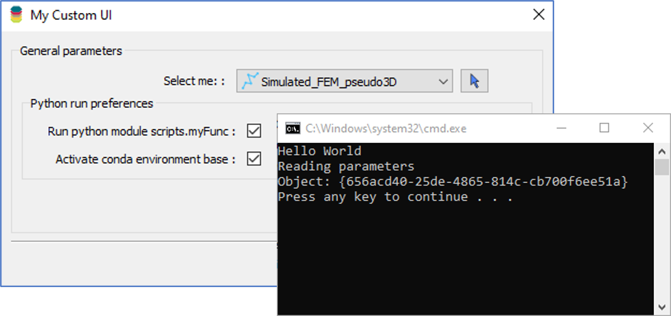
Using Python in Geoscience ANALYST Pro – Virtual Lecture
Past event, link available here...

Custom discrete colour scales
Geoscience INTEGRATOR allows you to build and display custom colour scales when making a scatter plot or...

Peak finder – Geoscience ANALYST geoapps: Python application
Past event. Link to recording available here.

Drape Voxet properties on surfaces
In GOCAD Mining Suite you can texturally drape your images and 2D gridded data onto surfaces, for example...

VPmg, VPem1D and VPutility release
VP Geophysics Suite releases: VPmg version 9.3, VPem1D version 4.3 and VPutility version 1.2...