


Maximizing value: 3D data integration and interpretation
One of the main challenges in exploration is increasing our subsurface knowledge. Add to this the desire to reduce exploration risks and maximize success of discovering new resources. Nowadays scientists work with a wide range of raw and processed data, geological interpretations, and concepts. New technologies for 3D data integration and interpretation are essential, but the approach is not simple. In some instances, you have mountains of historical data that need to be brought in a real 3D interpretation environment, while in others, you have very little geological data making geophysical modelling essential to test geological hypothesis. Increasing knowledge demands effort and resources.
Two years ago, Mira Geoscience started working with Ero Copper Corp on the Curaçá Valley project by providing an integrated approach supported by geological understanding. From observation to computation, we helped in the creation and delivery of meaningful, client-driven integrated 3D models that served as the basis for decision making and discoveries.
Case study: Curaçá Valley copper mine/project area, Brazil
The Curaçá Valley project is a great example of adapting an exploration approach to the different types of data available. It all started with data management. We compiled historical geological, geophysical and geochemical data in GOCAD Mining Suite. This was followed by a thorough QA/QC of the geoscientific database. Finally, 2D surface data were brought into a 3D modelling environment, allowing the creation of 3D models.
Caraíba (Pilar mine) area is a near mine exploration project rich in data. New findings at depth called for a re-evaluation of the historical synform model. The deposit is now considered related to a steeply-dipping intrusion. Using structural field interpolations, in GOCAD Mining Suite – Sparse, a new model of the foliation families was created using historical structural data. The predictive model pointed to a high mineral potential zone near the contact between two foliation planes. This model was confirmed by the finding of a new mineralization intercept almost 500 m below the mine infrastructure.

Caption: Caraíba - new mineralization intercept almost 500 m below the mine infrastructure.
©2018 Ero Copper Corp. All rights reserved
Due to the lack of geological data at depth in the Vermelhos project area, we applied the classical data-driven approach of Weights-of-Evidence using 3D properties (mostly geophysics) as predictors in GOCAD Mining Suite – Targeting Workflow. The near surface main mineralized area was used as training data in order to find similar signatures elsewhere in the volume of interest. The predictive model indicated mineralization 200 m below the main mineralized area. In parallel to this, an ongoing review of historical electromagnetic (EM) surveys determined that the mineralization produced moderate, but appreciable conductive responses. A systematic Borehole EM program and interpretation of this data through plate modelling pointed to satellite mineralization. Both the predictive and BHEM targets were confirmed by drilling.

Caption: Caption: Vermelhos – new satellite mineralization.
©2018 Ero Copper Corp. All rights reserved
The success we had in broadening our knowledge made us confident in using similar workflows, processes and techniques at depth and larger scale throughout the Curaçá Valley. With modelling results indicating that a Vermelhos-type mineralization could be detected at roughly 200m depth, a state-of-the-art airborne EM program was designed as the next phase of exploration.
Scott Napier, P.Geo – Senior Geophysicist with Mira Geoscience
Scott leads this project with James Reid, Glenn Pears, Thomas Campagne, Pablo Letelier, and Jean-Philippe Paiement. Scott brings general expertise in geophysical inversion, along with extensive borehole, ground, marine, and airborne EM interpretation and processing experience. He has worked in Canada and internationally on oil and gas, uranium, and base metal exploration teams, with a track record of proven discovery.
Latest news

Behind the Scenes: A Technical Deep Dive – Chasing Innovation From the Ground Up

GOCAD Mining Suite – A geological modelling powerhouse

Assign geological features

Importing objects from project

FAQ – Can I use v18 with v17u2?
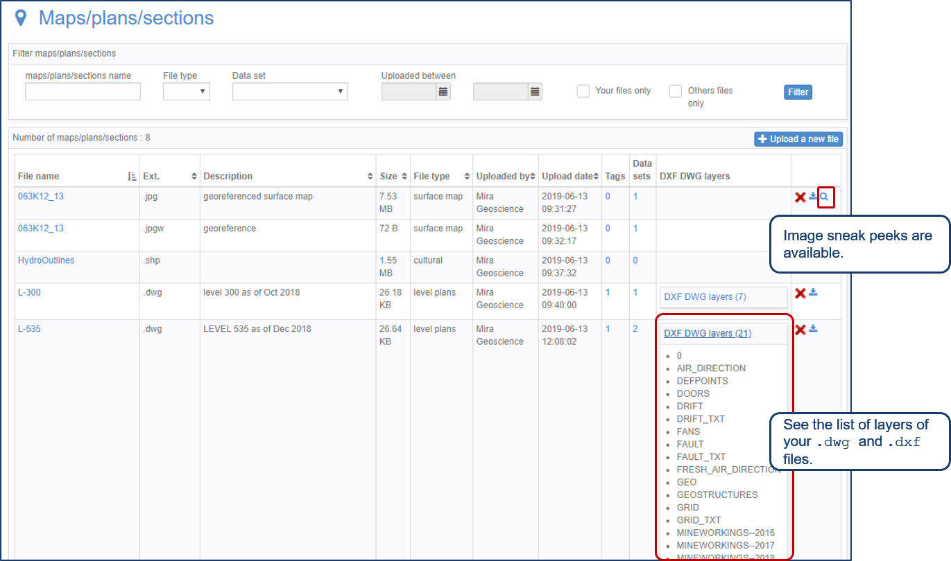
Preview files in the Maps/plans/sections page

Building a geological framework from exploratory modelling of magnetic data – Virtual Lecture

Attaching files

Macros

Reopening selected commands

